


Canadian Mapping Skills: An Introduction to Mapping Grades 1-2
EBJ166
$32.99 CAD
Additional information:
- Author : Golletz, Lynda
Build strong early mapping skills with Canadian Mapping Grades 1–2! This comprehensive resource introduces young learners to Canada’s shape, location, and major features while teaching essential map‑reading skills. Students explore globes, hemispheres, symbols, legends, grids, and directions through hands‑on activities that include mapping rooms, parks, schoolyards, and neighbourhoods.
Aligned with Social Studies expectations across all Canadian provinces and territories, this resource supports spatial awareness, community understanding, and geographic vocabulary development. With clear teacher notes, engaging worksheets, and real‑world mapping tasks, it’s the perfect foundation for early geography learning.
Ideal for Grade 1–2 classrooms, homeschoolers, and Canadian Studies units.
-
Teacher Rubric
- Student Rubric
-
Teacher Information
-
Glossary of Geographic Terms
-
Assessment One (The Globe - Student Sheet)
-
Assessment One ( The Globe)
-
Assessment Two (Canada in the World)
-
Answer Key
- Canada in the World (Locating Canada)
- Canada in North America (Locating Canada)
- Our Country Canada (Map)
- The Shape of Canada (Basic Shape of Canada)
- Show Me Canada (Recognizing Canada’s Shape)
- Canada Puzzle (Recognizing Canada’s Shape)
- My Canada Puzzle (Recognizing Canada’s Shape)
- Canada From Space (Satellite Image)
- Explore Canada From Space (Internet Activity)
- A Globe (What is a globe?)
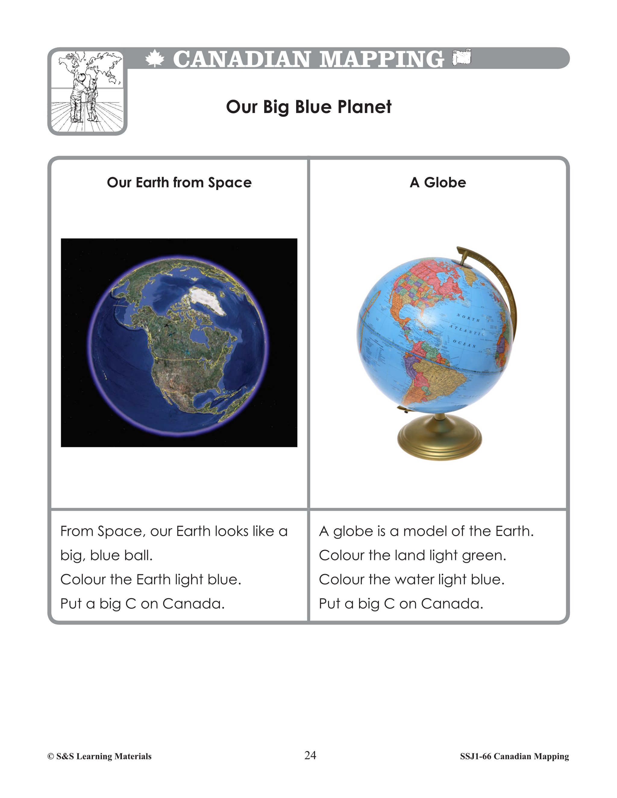
- Our Big Blue Planet (Comparing Satellite Image with a Globe)
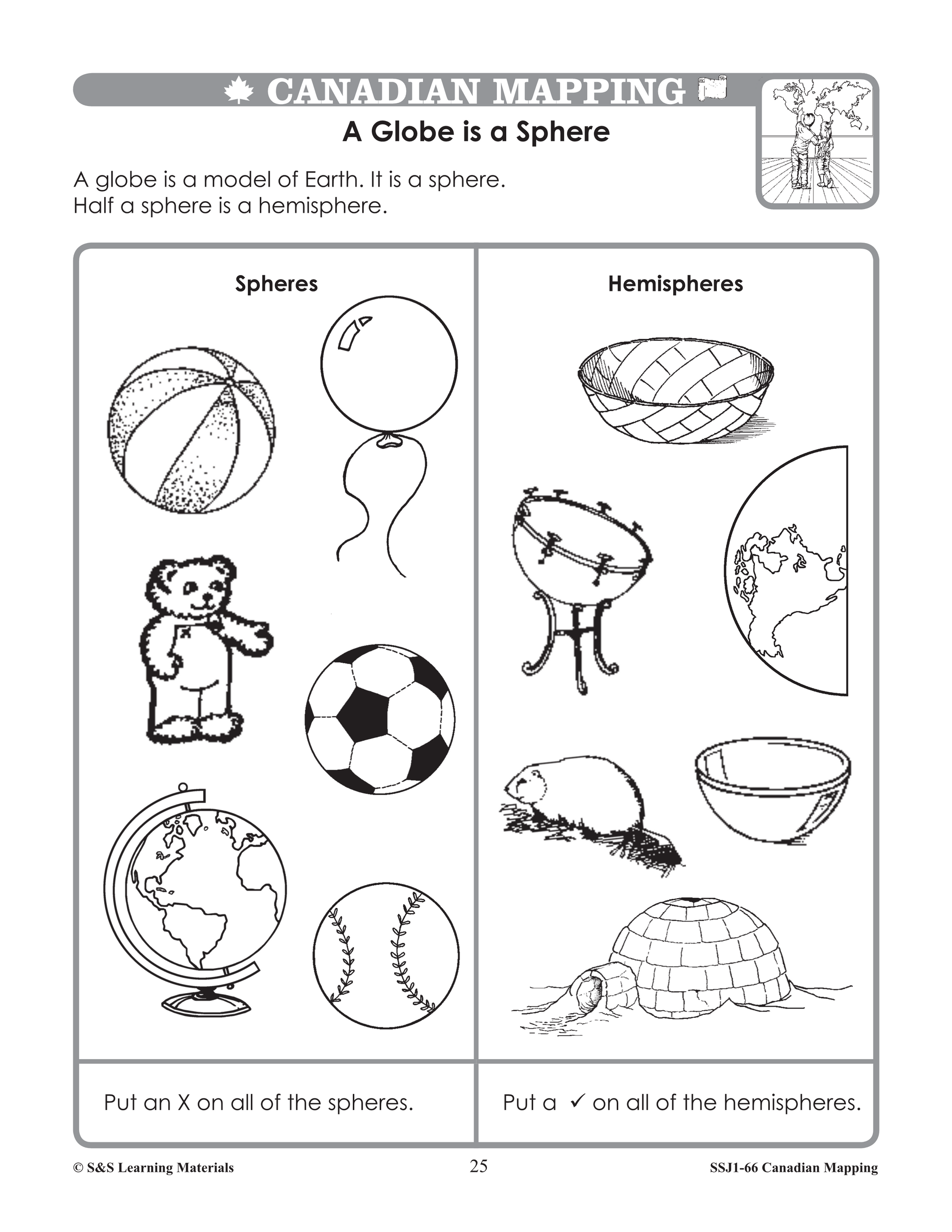
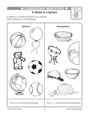
- A Globe is a Sphere (Earth is a sphere)
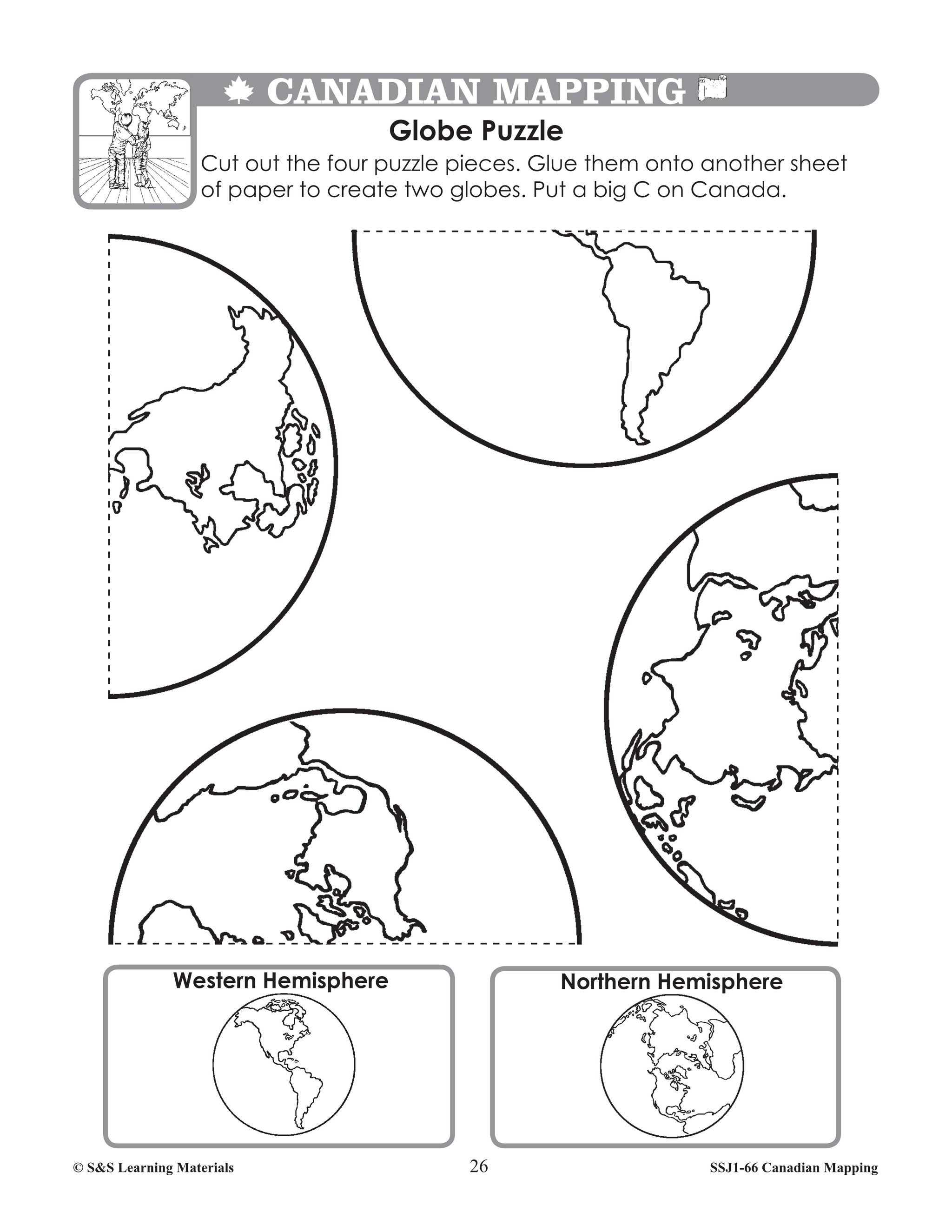
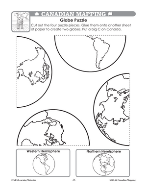
- Globe Puzzle (Spheres and Hemispheres)
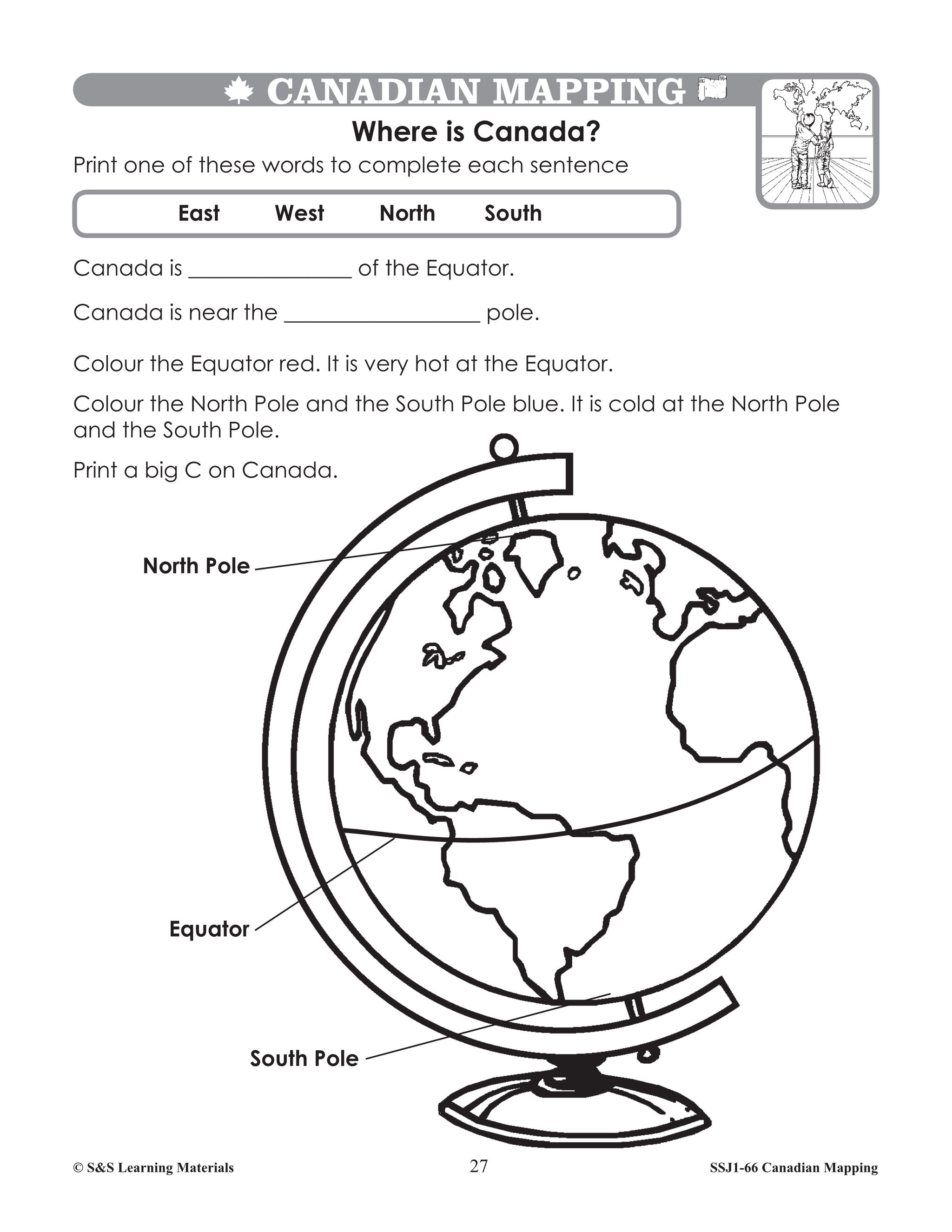
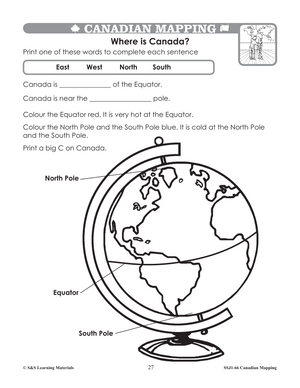
- Where Is Canada? (Locating Canada on a Globe)
- Canada Sort (Read and Interpret a Globe, Equator, Poles, and Hemispheres)
- Where in the World is Canada? (Read and Interpret a Map, equator and hemispheres)
- Where in the World is It? (Locating Places on a Map of the World)
- Mapping Canada (Maps for Many Uses)
- More Mapping Canada (Many Kinds of Maps)
- Symbols of Canada (What is a Symbol?)
- Neighbourhood Map (Map Legend and Symbols)
- Map a Room! (Using Symbols)
- Mapping Our Kitchens (Create Symbols)
- A Map of My Kitchen (Create a Map Using symbols)
- Canadian Cities (Symbols for Main Cities)
- Finding Canadian Cities (Locating Canadian Cities)
- Colouring Canada (Colour on a Map of Canada)
- Colours on a Map (Colour Denotes Political Boundaries)
- Compass Rose (Cardinal Directions)
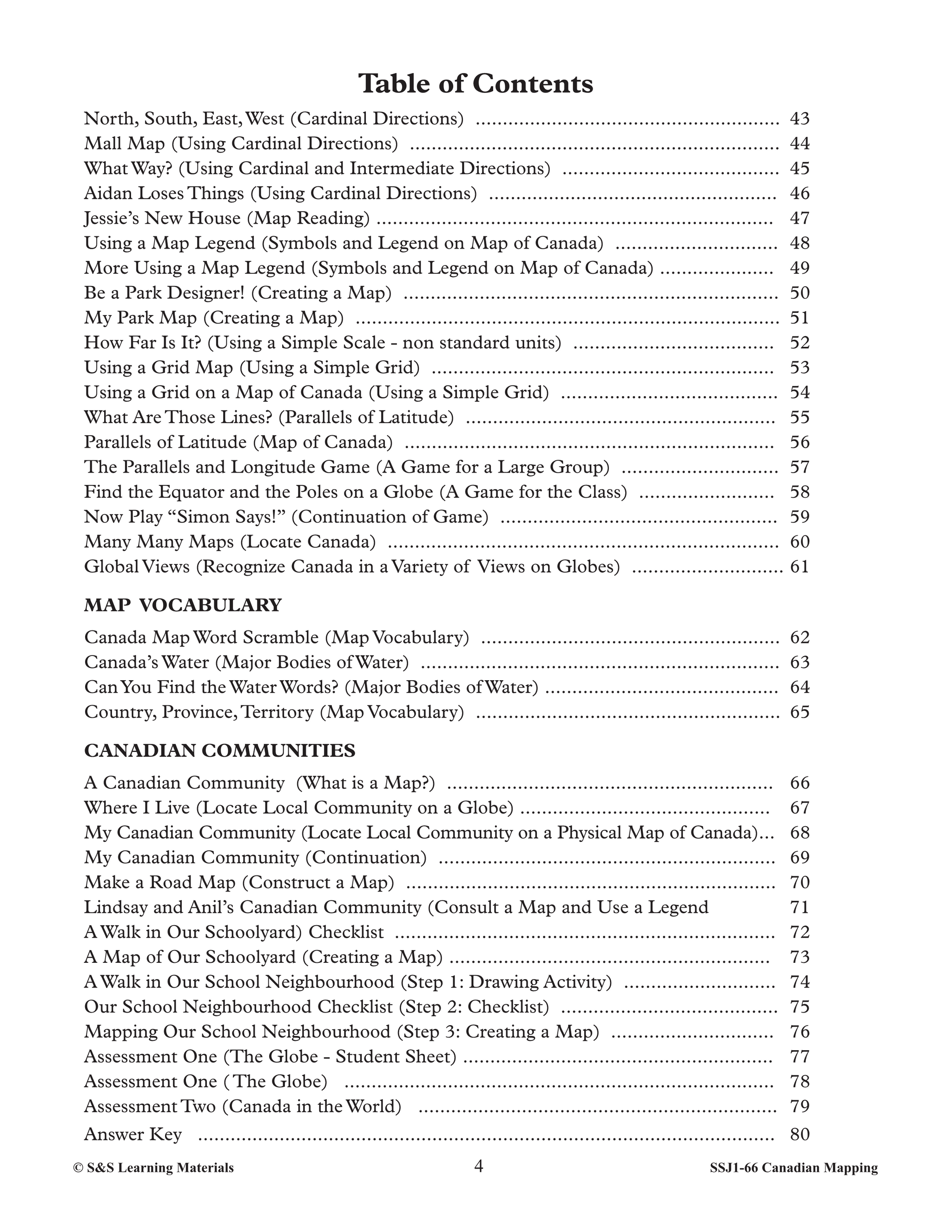
- North, South, East, West (Cardinal Directions)
- Mall Map (Using Cardinal Directions)
- What Way? (Using Cardinal and Intermediate Directions)
- Aidan Loses Things (Using Cardinal Directions)
- Jessie’s New House (Map Reading)
- Using a Map Legend (Symbols and Legend on Map of Canada)
- More Using a Map Legend (Symbols and Legend on Map of Canada)
- Be a Park Designer! (Creating a Map)
- My Park Map (Creating a Map)
- How Far Is It? (Using a Simple Scale - non standard units)
- Using a Grid Map (Using a Simple Grid)
- Using a Grid on a Map of Canada (Using a Simple Grid)
- What Are Those Lines? (Parallels of Latitude)
- Parallels of Latitude (Map of Canada)
- The Parallels and Longitude Game (A Game for a Large Group)
- Find the Equator and the Poles on a Globe (A Game for the Class)
- Now Play “Simon Says!” (Continuation of Game)
- Many Many Maps (Locate Canada)
- Global Views (Recognize Canada in a Variety of Views on Globes)
- Canada Map Word Scramble (Map Vocabulary)
- Canada’s Water (Major Bodies of Water)
- Can You Find the Water Words? (Major Bodies of Water)
- Country, Province, Territory (Map Vocabulary)
- A Canadian Community (What is a Map?)
- Where I Live (Locate Local Community on a Globe)
- My Canadian Community (Locate Local Community on a Physical Map of Canada)
- My Canadian Community (Continuation)
- Make a Road Map (Construct a Map)
- Lindsay and Anil’s Canadian Community (Consult a Map and Use a Legend
- A Walk in Our Schoolyard) Checklist
- A Map of Our Schoolyard (Creating a Map)
- A Walk in Our School Neighbourhood (Step 1: Drawing Activity)
- Our School Neighbourhood Checklist (Step 2: Checklist)
- Mapping Our School Neighbourhood (Step 3: Creating a Map)
Canadian Curriculum Expectations Met by Canadian Mapping Grades 1–2
Ontario – Grade 1 & 2 Social Studies
Grade 1 – Our Changing Roles and Responsibilities / The Local Community
- Use maps to identify places in the community
- Create simple maps using symbols and legends
- Identify land and water on maps
- Use cardinal directions
- Recognize Canada as part of the world
Grade 2 – Global Communities
- Identify Canada on maps and globes
- Compare communities using maps
- Use map features (legends, symbols, grids, directions)
- Recognize continents, countries, and regions
Direct evidence:
“Recognize that the world is made up of countries, continents, and regions.”
“Make and read concrete, pictorial, and simple maps…”
British Columbia – Grade 1 & 2 Social Studies
Big Ideas & Content:
- Relationship between people and places
- Use of maps to represent familiar and global places
- Understanding globes, hemispheres, and directions
- Identifying Canada and its place in the world
Direct evidence:
“Identify a variety of maps and locate Canada on them.”
“Recognize and use pictorial symbols, colour, legends, keys, and cardinal directions…”
Alberta – Grade 1 & 2 Social Studies
Grade 1: My World
- Mapping familiar places (school, home, community)
- Using symbols and simple legends
- Understanding globes and maps
Grade 2: Canada’s Dynamic Communities
- Identifying Canada on maps
- Recognizing land, water, and regions
- Using cardinal directions
Direct evidence:
“Make and read maps of familiar areas in their local community.”
“Where is Canada? (Locating Canada on a Globe).”
Saskatchewan – Grade 1 & 2 Social Studies
Outcomes:
- Understanding place and environment
- Representing familiar places using maps
- Using symbols, legends, and directions
- Recognizing Canada’s location globally
Direct evidence:
“Use maps to locate information about their own community.”
“Recognize that maps represent real places.”
Manitoba – Grade 1 & 2 Social Studies
Cluster 1 & 2:
- Exploring the local community
- Using maps, globes, and symbols
- Identifying Canada and North America
- Understanding land, water, and spatial relationships
Direct evidence:
“Recognize Canada as part of North America.”
“Use appropriate map vocabulary.”
Québec – Cycle 1 Social Sciences
Geography & Citizenship:
- Understanding territory and spatial organization
- Using maps, symbols, and directions
- Identifying Canada and the world
- Locating familiar places
Direct evidence:
“A globe is a model of the earth.”
“Where in the World is It? (Locating Places on a Map of the World).”
Atlantic Provinces (NS, NB, PEI, NL)
Grade 1–2 Social Studies Themes:
- Mapping the classroom, school, and community
- Using symbols, legends, and directions
- Identifying Canada and the world
- Recognizing land and water
Direct evidence:
“Mapping Our Schoolyard… Mapping Our School Neighbourhood.”
“Canada in the World (Locating Canada).”
Yukon, Northwest Territories, Nunavut – Grade 1 & 2 Social Studies
Themes:
- Understanding place and community
- Using maps and globes
- Identifying Canada and the circumpolar world
- Recognizing land, water, and directions
Direct evidence:
“Find the Equator and the Poles on a Globe.”
“Canada’s Water (Major Bodies of Water).”
You may also like:
Canadian Daily Language Activities
Canadian Math Google Slide Activities
Subscribe to our Fan List!: Our FANlist newsletter is full of tips on ways to save time with our resources, exclusive sales, new product info and free monthly downloads – you won’t want to miss out!
Follow us on:
![]()
![]()